


スーパー地形 - GPS対応地形図アプリ
Description of スーパー地形 - GPS対応地形図アプリ
Note has an explanatory article. Search for "note super terrain"!
Received the 2018 Japan Cartographic Society Award for Best Work.
- You can use "super terrain data" that emphasizes terrain using unique technology.
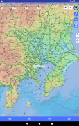
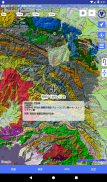
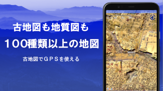
- You can use the Geospatial Information Authority of Japan's Geographical Survey Institute maps, topographic maps, geological maps, old maps, past and present maps, and prewar topographic maps (Ordnance Survey Department).
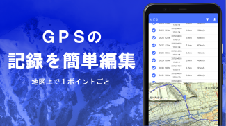
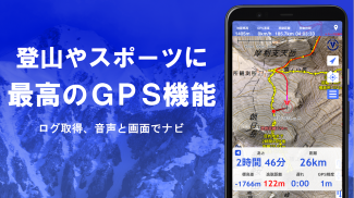
- Tracks (trajectories) can be recorded using the GPS function. GPX log input/output and editing functions are also available.
- Equipped with functions to support walking around town, mountain climbing, and outdoor activities, such as GPS navigation (with audio) and data recording and editing.
- There is a visibility determination function that can be used for creating cross-sectional diagrams, observation, radio, etc. Buildings can also be displayed.
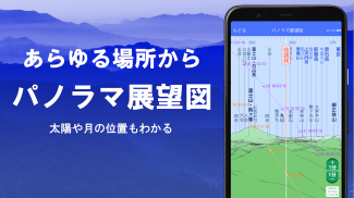
- Equipped with 360° panoramic view function. It is a mountain identification function that allows you to know the name of the mountain. It is also possible to display the sun, moon, and GPS points.
- GPS function, bulk map download, and map cache function that can be used comfortably offline when there is no radio signal when climbing or outdoors.
- You can associate photos with points.
- Contour lines generated from elevation data can be displayed.
- MGRS grid (UTM grid) can be displayed.
- Read, display and edit GIS data from GeoJSON files.
- It is possible to draw shapes.
- Can be used overseas.
- Map printing and PDF output are possible.
- Supports dark theme.
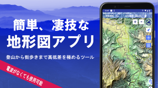
1. A wealth of maps that can be used
Usable maps (more than 100 types including combinations)
We have our own super topographic data, maps from the Geospatial Information Authority of Japan, hazard maps, etc.
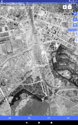
* Regarding aerial photographs (by age group), there may be locations where there are no photographs depending on the age group. "Latest" and "around 1974" have relatively wide coverage areas.
*Map using super terrain data can be used for free for 5 days after installing the app.
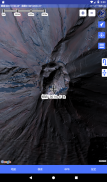
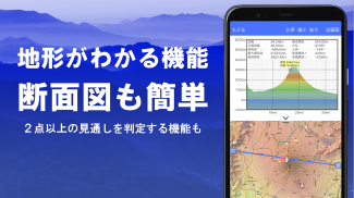
2. Creation of cross sections and outlooks
You can easily draw a cross section through any point on the map.
In addition, it is equipped with the familiar visibility judgment function in Kashmir 3D. Calculations can be made that take into account the roundness of the earth and atmospheric differences.
It is useful for checking routes while climbing, determining wireless visibility, and understanding the terrain.
Where PLATEAU building data is available, you can create a cross-sectional view that includes the building.
3. Elevation palette function
By using the elevation palette function, you can change the color of the map background and change it to your favorite color (gradation) in 1cm increments.
4. panoramic view
You can display a panoramic observation map where you can see the name of the mountain from anywhere on the map. A 360 degree panorama that can be linked to your smartphone's compass. Demonstrates its power in identifying mountains.
You can display the sun and moon (including the moon phase). It can be used to explore Diamond Fuji and Pearl Fuji.
You can also view the location of GPS points.
You can also draw panoramic views of mountains overseas.
5. GPS function
You can also obtain location information using your smartphone's GPS and record tracks.
Adopts high-precision position measurement that can withstand serious mountain climbing and outdoor use.
Recorded tracks can be displayed graphically with parameters such as height difference, speed, time, and elapsed time.
With the point alarm function, you will be notified by voice and alarm sound when you approach a point.
You can display photos associated with points.
You can send the map center position to NaviCon.
6. GPS track summary playback
This function allows you to play back track tracks all at once.
It compares the shooting times of photos stored on your smartphone and automatically displays matching photos.
An icon will be displayed at the photo location and it will be displayed by tapping it.
7. GPS navigation function
Equipped with a function (Track Navi) that allows you to navigate along preset tracks using your smartphone's GPS.
If you deviate from the track, a voice or alarm will sound.
This will definitely prevent you from getting lost while climbing.
In addition, route navigation using route data that is convenient for walking around town, and point navigation that aims at one point are also possible.
8. GPS data editing function
It can handle GPS-related point, route, and track data.
You can manage by folder. It is displayed in an easy-to-read tree format.
It is also possible to create tracks directly on the map.
You can also import and export in GPX format from mountain climbing sites, etc.
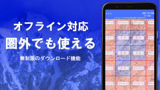
9. Map usage outside the service area (offline)
Maps can be used even when going mountain climbing or other areas where there is no signal.
The bulk download function ensures that you can download all scale maps of the specified plot.
You can see at a glance what is being downloaded. This will prevent situations where you don't have a map on site.
There is also a cache function.
10. Map history function
Memorize what you have seen once. It is possible to return to the previous location.
11. Custom map compatible
You can import and use custom maps cut out with Kashmir 3D's map cutter.
You can display and use your own maps and scanned maps as maps.
When using the map cutter, divide each image into approximately 256 x 256 images.
Please send the created kmz file to Super Terrain using email or Cloud Drive.
12. GeoJSON compatible
You can display and edit points, linestrings, and polygons from GeoJSON format files.
You can draw new shapes.
13. Print/PDF output
You can print any area of the map with a specified scale or create a PDF.
14. Cooperation with other apps
GPS data can be input and output in GPX format, KML format, and GDB format.
It is possible to exchange data with other applications, the software ``Kashmir 3D'' on your PC, and use trajectory data from mountain climbing sites.
15. Backup function
All data in the app (excluding maps such as cache) can be backed up and removed from the smartphone.
If you take it out, you can restore the data even if you delete the app or your smartphone malfunctions.
There is also an automatic backup feature using Google Drive. Always maintain up-to-date backups.
Please see the manual for details.
16. About billing function
Some functions, such as maps using super terrain data, GPS track functions, and cross-sectional views, are subject to in-app purchases. Also, after paying, the number of search results for place name searches will increase.
●Fees
Annual payment: 780 yen/year
●Free trial
You can try the app for free for 5 days after first installing it.
After 5 days, some features and maps will no longer be available.
You will not be charged unless you perform a purchase operation.
To purchase, please select [Settings] - [Purchase to remove functional restrictions] within the app.
●Confirmation and cancellation
You can check the automatic update timing or cancel automatic update from the following.
1) Open Google Play
2) Press "Regular Purchase" from the menu
3) Select "Super Terrain"
●Price revision
Prices may be revised due to future feature enhancements.
It is advantageous to purchase early.
17. Terms of use
The copyright holder and developer assume no responsibility for the results of operating this application.
When you start GPS for the first time, a message will appear asking "Do you want to allow the use of location information services?" Please allow it.
Continuous use of the GPS function will drain the battery.
If your device is also used for emergency communication, please take precautions such as carrying a spare battery.
An easy-to-understand explanation of the navigation function is provided below in PDF format.
https://www.kashmir3d.com/online/superdemapp/superdem_navi.pdf
When recording tracks with some smartphones, the recording may be interrupted or may not be possible.
This is because the power saving function forcibly closes the background app, and the app side
I can't deal with it. A similar phenomenon is occurring with other apps as well.
If you turn off the light while the super terrain is displayed, the recording will persist for a while, but this is a fundamental solution.
Not. note that.
スーパー地形 - GPS対応地形図アプリ - Version 4.7.8
(07-05-2025)スーパー地形 - GPS対応地形図アプリ - APK Information
APK Version: 4.7.8Package: com.kashmir3d.superdemLatest Version of スーパー地形 - GPS対応地形図アプリ


 3.98
3.98Apps in the same category

You may also like...


